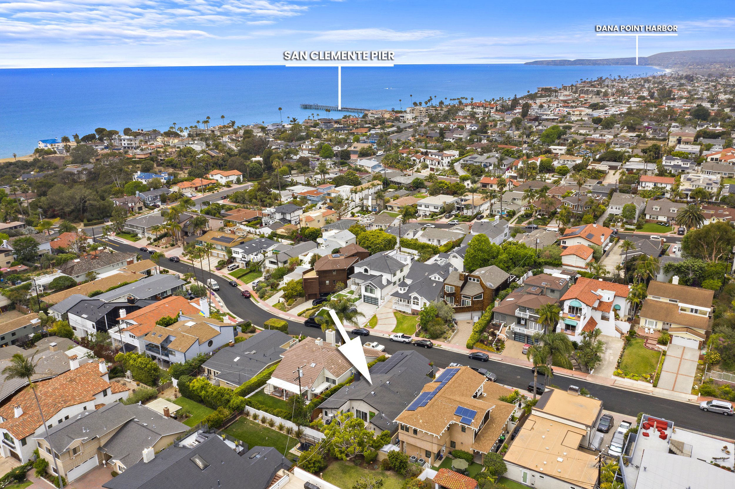
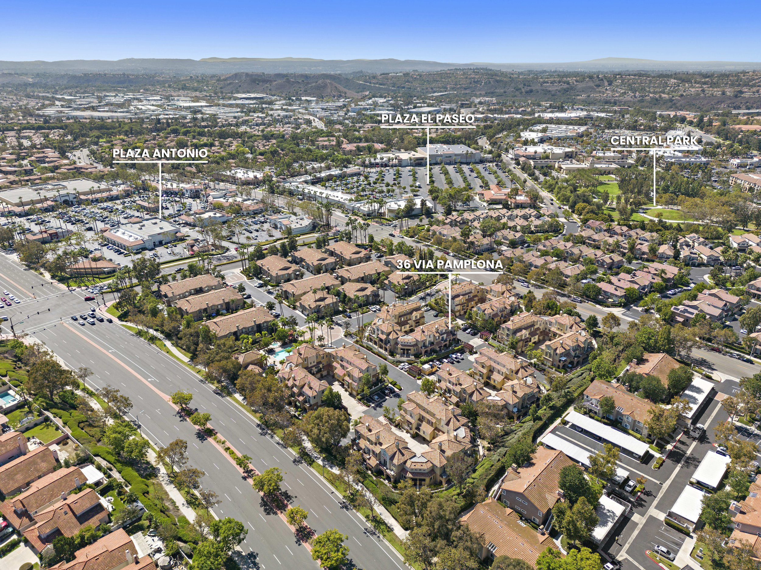
0
Skip to Content
BOWMAN GROUP MEDIA
PHOTO
VIDEO
MORE COOL STUFF
ZILLOW 3D TOUR
TWILIGHT CONVERSION
VIRTUAL STAGING
CUSTOM PROPERTY SITE
MATTERPORT 3D TOUR
3D FLOORPLAN
VIRTUAL TOUR
DRONE ADD-ON GEOTAG
MARKETING
PRESS
PUBLICATIONS
TESTIMONIALS
CONTACT US
BOOK NOW
BOWMAN GROUP MEDIA
PHOTO
VIDEO
MORE COOL STUFF
ZILLOW 3D TOUR
TWILIGHT CONVERSION
VIRTUAL STAGING
CUSTOM PROPERTY SITE
MATTERPORT 3D TOUR
3D FLOORPLAN
VIRTUAL TOUR
DRONE ADD-ON GEOTAG
MARKETING
PRESS
PUBLICATIONS
TESTIMONIALS
CONTACT US
BOOK NOW
PHOTO
VIDEO
Folder: MORE COOL STUFF
Back
ZILLOW 3D TOUR
TWILIGHT CONVERSION
VIRTUAL STAGING
CUSTOM PROPERTY SITE
MATTERPORT 3D TOUR
3D FLOORPLAN
VIRTUAL TOUR
DRONE ADD-ON GEOTAG
MARKETING
Folder: PRESS
Back
PUBLICATIONS
TESTIMONIALS
CONTACT US
BOOK NOW

POINTS OF INTEREST GEOTAG

Aerial view of a coastal neighborhood with houses, streets, trees, and two labeled locations, San Clemente Pier and Dana Point Harbor, with ocean in the background. View fullsize
An aerial view of a residential neighborhood with labeled landmarks including Oso Grande Elementary, Oso Grande Park, and a street called 9 Chiante. The scene features houses with red-tile roofs, green trees, and mountains in the distance under a par View fullsize
Aerial view of a coastal city with a marina, numerous boats on the water, and closely packed houses along the shoreline. The city skyline is in the background with tall buildings under a partly cloudy sky. View fullsize
Aerial view of a residential neighborhood with labels identifying local landmarks such as Arroyo Vista Elementary and Middle School, Arroyo Vista Park, 241 Toll Road, Tijeraso Creek Golf Course, and 4 Charca, with mountains in the background under a View fullsize
Aerial view of a residential neighborhood showing rooftops, a street with parked cars, and a marked rectangular area measuring 30 feet by 70 feet. View fullsize
Aerial view of a coastal neighborhood with labels indicating Las Palmas Elementary School, beach access at 204, Dana Point Harbor, and the address 155 W Mariposa, showing houses, streets, and the ocean in the background. View fullsize
Aerial view of a residential neighborhood with labeled locations including Plaza Antonio, Plaza El Paseo, Central Park, and 36 Via Pamplona, showing streets, houses, parking lots, and green spaces under a clear blue sky. View fullsize
Aerial view of a residential neighborhood with a clubhouse and pool marked as Dana Vista, overlooking the ocean and coastline in the background. View fullsize
Aerial view of a suburban neighborhood with labeled parks and landmarks including Poets Park, 26 Tuberose, Oso Grande Park, and Oso Grande Elementary, showing residential streets, houses, and surrounding hills. View fullsize
An aerial view of a neighborhood with labeled landmarks: St Junipero Serra Catholic School, 241 Toll Road, Tijeras Creek Golf Course, and 4 Charca, with houses, trees, a pond, and distant hills. View fullsize
Aerial view of a coastal neighborhood with houses, a road, and the ocean on the left side under a clear blue sky. View fullsize
Aerial view of a residential neighborhood near the coast with houses, streets, trees, and mountains in the background. Text overlays identify locations including 155 W Mariposa, Avenida del Mar, and San Clemente Pier. View fullsize
Aerial view of a coastal neighborhood with houses, streets, trees, and two labeled locations, San Clemente Pier and Dana Point Harbor, with ocean in the background.
An aerial view of a residential neighborhood with labeled landmarks including Oso Grande Elementary, Oso Grande Park, and a street called 9 Chiante. The scene features houses with red-tile roofs, green trees, and mountains in the distance under a par
Aerial view of a coastal city with a marina, numerous boats on the water, and closely packed houses along the shoreline. The city skyline is in the background with tall buildings under a partly cloudy sky.
Aerial view of a residential neighborhood with labels identifying local landmarks such as Arroyo Vista Elementary and Middle School, Arroyo Vista Park, 241 Toll Road, Tijeraso Creek Golf Course, and 4 Charca, with mountains in the background under a
Aerial view of a residential neighborhood showing rooftops, a street with parked cars, and a marked rectangular area measuring 30 feet by 70 feet.
Aerial view of a coastal neighborhood with labels indicating Las Palmas Elementary School, beach access at 204, Dana Point Harbor, and the address 155 W Mariposa, showing houses, streets, and the ocean in the background.
Aerial view of a residential neighborhood with labeled locations including Plaza Antonio, Plaza El Paseo, Central Park, and 36 Via Pamplona, showing streets, houses, parking lots, and green spaces under a clear blue sky.
Aerial view of a residential neighborhood with a clubhouse and pool marked as Dana Vista, overlooking the ocean and coastline in the background.
Aerial view of a suburban neighborhood with labeled parks and landmarks including Poets Park, 26 Tuberose, Oso Grande Park, and Oso Grande Elementary, showing residential streets, houses, and surrounding hills.
An aerial view of a neighborhood with labeled landmarks: St Junipero Serra Catholic School, 241 Toll Road, Tijeras Creek Golf Course, and 4 Charca, with houses, trees, a pond, and distant hills.
Aerial view of a coastal neighborhood with houses, a road, and the ocean on the left side under a clear blue sky.
Aerial view of a residential neighborhood near the coast with houses, streets, trees, and mountains in the background. Text overlays identify locations including 155 W Mariposa, Avenida del Mar, and San Clemente Pier.

Book Your Shoot with Us Today!

BOOK NOW
BGM Logo White Text.png

© 2025 Bowman Group Media

 Privacy Policy / Terms of Service

NAVIGATE

Contact Us

Travel Fee
Cancellation Policy

Testimonials
Press
Licensing Agreement

GALLERIES

Day Photos
Twilight Photos
Drone Photos

Twilight Conversion
Virtual Staging
Video

DEEP DIVES

Drones
Twilight
3D Matterport Tour

Tutorial Videos

MARKETING

Events
Commercial
Restaurants